Southern Pacific Shasta Division Engineering Department Maps from Shasta Division Archives:.................................
|
|
The Complete Deetz*
latest additions: 8-14-25, 9-14-25
|
* Yeah, we know: "Why all of this effort on a place that nobody cares about?" Well, Deetz is within a couple of miles of Wx4's summer office, so Staff does care. |
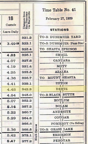
Deetz's place in the 1929 timetable. At the time, it was a flag stop for a mid-afternoon train in each direction (click on the image for the full timetable)
|
Deetz is nearby the former site of a quarry and rock crusher located at the foot of Black Butte, just north of the I-5 summit. The quarry's location is still quite apparent just east of the freeway behind Truck Village (behind all of the gaudily painted water trucks for sale).
Apparently the quarry opened during the construction of the Central Pacific main line in the 1880's, but the date tracks were laid to it is unclear. The SP siding and spurs were originally called Dietz, although the location did not find its way into employee timetables until sometime between 1899 and 1907. Likewise, so far the date that the station's name transformed into Deetz is unknown, but occurred sometime in the 1911-12 period.
As a passenger stop, Deetz was a figurative word-of-mouth flag stop that showed up in employee timetables, but never in public ones as near as can be told. Typically, two trains per day stopped on flag, although for awhile in 1914, an additional pair of trains were subject to flagging. Deetz passengers never benefitted from a proper depot. A telegraph office was proposed in 1921, but does not show on subsequent maps. The 1926 map does show a "station", which suspiciously had the shape of a boxcar. The flag stop survived until at least 1932, but was gone by 1941.
In 1927, engineers proposed line change (see maps) to straighten out the winding uphill grade between Deetz and Black Butte. This was completed in 1930, despite pending land condemnation litigation. completion until 1930. When the line adjustment was actually constructed is unknown, but it shows in the 1946 map. As the maps tell us, the quarrying operation was shut down and the ballon track, wye, yard and SP buildings were all removed in the late 1930's.
In later times, SP m/w installed a loose wheel detector at Deetz, which stood a a bottom of a swale. Had operating officials been consulted about its location, it would have been placed elsewhere. Slack adjustments between the cars commonly occur in swales (run-ins can occasionally be heard from Wx4's summer office more than a mile away), sometimes causing trucks to skew enough to trick the detecter into thinking it had found a loose wheel (loose wheels are an exceedingly rare thing). The end result was that when a loose wheel was not found on the suspect car, the inside of the wheels on several cars on either side had to likewise be inspected from underneath by a brakeman, a very time consuming task. the detector was later removed.
|
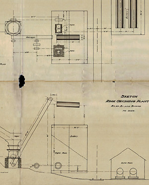
Deetz rock crusher (see drawing)
|
Unless otherwise noted, these drawings were scanned from linen originals of varying length and size. The originals of entries denoted as (LL) are of roughly letter or legal size paper.
- NEW 9-14-25: "Dietz" 1904-08-09 The location, an apparently busy place - with evidence of already being considerably rearranged by then, the place did not have station building or SP office.
- "Diez" 1910-12-00 "Spur To Old Rock Crusher on Black Butte - Mountain Showing Right of Way to be acquired from McCloud R.R.R. Co." - brownprint - Whether the tracks were laid earlier on right of way leased from MRRR is unclear.
- NEW 8-14-25: Deetz 1912-08-02 Hudson Lumber Co. lease for log storage grounds (LL)
- Deetz 1920-01-00 "Spur to Old Rock Crusher on Black Butte Mountain" - blueprint contour map - Bisecting the balloon track is the California State Highway, later U. S. 99 and now Summit Road. Bumps in Summit Road's pavement suggest that the rails re still there. I-5 currently lays to the immediate map right of the road, while Truck Village (where a dealer displays a multitude of brightly colored commercial tanker trucks) is situated at the site of the old rock crusher. The quarry site behind is quite evident today.
- Deetz 1921-07-13 "Construct Telegraph Office And Operator's Dwellings" - blueprint - The office appears tohave be created from a re-purposed boxcar. It shows as a "station" in the 1926 map. The first listed 1940 map shows a building and an outhouse at the 1921's proposed dwellings site. It is not known if an operator actually manned the telegraph office, but employee timetables indicate that it never was a train order office.
- Deetz 1926-07-00 "Station Map" - brownprint - Labeled Structures include a station, freight platform and tool house, but the interior of the wye shows no buildings.
- Deetz 1927-04-20 "Proposed Line Change" - blueprint - Drawing shows three alternatives for rducing the tight curve at the foot of the short grade between Deetz and Black Butte., along with the active and abandoned original Central Pacific right of way and the 1927 alignment..
- Deetz 1927-05-20 "Proposed Line Change" - blueprint - This drawing shows the line decided upon. The new alignment entered service in 1931, after the adjudication of a land condemnation lawsuit in the courts.
- Deetz 1938-11-00 "Retire Rock Crusher Tracks" - (LL) - Exactly when the rock crusher shut down has yet to be determined.
- Deetz 1939-02-00 "Retire Yard Tracks" - (LL) - This is a less detailed version of the two 1940 drawings, below.
- Deetz 1940-04-00 "Retire Yard Tracks & Buildings" - (LL) - This map shows the local section gang's buildings, also to be removed.
- Deetz 1940-04-00 "StationMap" - brownprint - This map depicts today's Deetz Road as a dirt road on the old wye tail track alignment.
- Deetz 1940-07-00 "Transfer RofW to non-carrier acct" - (LL) Presumably, this was done prepatory to sale.
- Deetz 1946-09-00 "Proposed Line Change" - brownprint - The east end of the 1931-completed line change temporarily connected to the existing main line until 1946, when the last segment of the "B" line of 1927 proposal was completed. Note profile and chart enumerating the projects' overall curvature and gradient reductions.
- Deetz 1948-02-00 "Station Map" - brownprint - Deetz still had one auxiliary track of the siding. Both were later removed. Most of the former wye's tail track has been ceded to Siskiyou County for Deetz Road.
|
|
|
* Yeah, we know: "Why all of this effort on a place that nobody cares about?" Well, Deetz is within a couple of miles of Wx4's summer office.
|
|
|