|
Southern Pacific Shasta Division Engineering Department Maps From Shasta Division Archives....................................................................
|
Shasta Div. MapsxxxxSP Maps & TimetablesxxxxSP Index |
|
The (nearly) Complete Upton
revised 9-12-25-25
|
|
| Upton, California is one of those obscure railroad places that is only known to railroaders, locals and a few fans, despite its heavy employment as a siding for about the last 130 years and its location being very near the summer offices of Wx4. It sits at the southern base of a cinder cone called Black Butte (the railroad Black Butte is about six railroad miles timetable east), about 2.5 miles north of the City of Mt. Shasta (long called Sisson).
Central Pacific's Marysville, CA-Ashland OR, California & Oregon Railroad (not to be confused with the Portland-Ashland Oregon & California Railroad) built through Upton in late 1887. The location was called Wright's Spur initially, something apparently never reflected in timetables. Sometime between mid-1893 and mid-1896 the name Upton began to show in timetables as a siding and flag stop for the Oregon Express, the single pair of passenger trains on the Shasta Division at the time. Equally notable in 1896, McCloud River Railroad began building its line out of Upton over the southern flank of Mt. Shasta. Because of the steep topography, MRRR was forced to exit via a switchback. In the process, it built an enginehouse costing $158.99 at Upton, along with what must have been a fairly substantial agent's cottage, based upon its $500 cost.
About the time of MRRR's arrival, Syskiyou Lumber & Mercantile bought out the Wright operation. Presumably this was a wooden box factory as were the successor outfits that followed over the years. For many years SP operated a gravel quarry there which is still active as Sousa Ready Mix.
|
|
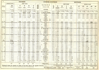
(click on the image) The earliest available SP timetable showing Upton is currently this one from 1896. Upton never gained "regular stop" status. - Tim Zukas; full timetable here
|
MRRR soon abandoned Upton in favor of Sisson, where it established a (now moribund, but still extant) small interchange yard with SP in 1907. It retained ownership of its land on the geographic east side of the SP tracks, continuing to lease the gravel pit to SP, and other land to a succession of box companies. By this time, industrial spurs existed on both sides of the SP main line. In 1911, SP straightened out its old C&O alignment between Sisson and Black Butte and again reduced curvature in the late 1920's, by which time the box industry and related tracks had disappeared. Aside from the gravel spur, all that remained were two oil distributors sitting along truncated spurs on either side of the main.
Subsequent quarrying and highway construction pretty well obliterated "historical" Upton. Today, UP maintains a spur off the siding to the quarry area, although it is lightly used. Although the former McCloud alignment eastward from Upton is now a dirt road, Interstate 5's Abram's Lake interchange, constructed in 1964, sits atop the switchback. As in the early days, two passenger trains still pass through Upton, but they don't stop.
Much of the above information comes from Jeff Moore and his McCloud Rails website. Jeff figures that Upton received its name circa 1894, but an unfortunate gap in the Wx4 and CSRM timetable collections between mid-1893 and mid-1896 has confounded confirmation so far.
|
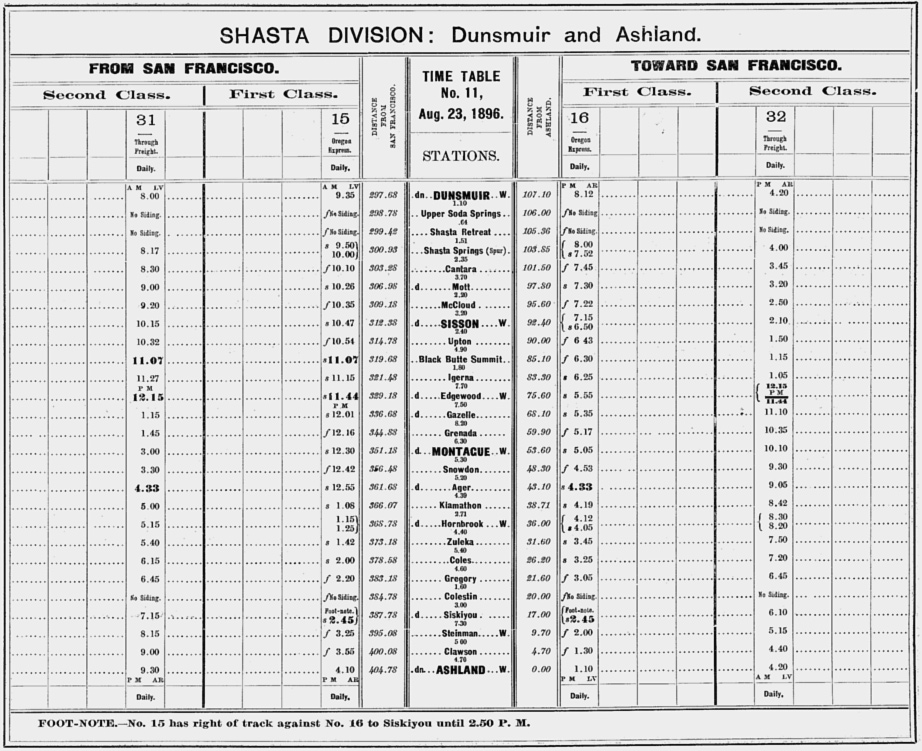
(click on the image) The Siskiyou Line was at full blossom in 1924, as seen above. Curiously, while public timetables ceased listing Upton effective with the opening of the Natron Cutoff through Klamath Falls in 1927, employee timetables continued showing Upton as a flag stop until at least August, 1932. - Tim Zukas full timetable here
|
|
Maps
Unless otherwise noted, these maps were scanned from linen originals of varying length and size.
SP engineering maps from Shasta Division Archives
1908-02-25 This drawing is a new one, not a revised older one, so there is no trace of McCloud River Railroad's switchback entrance into Upon, which is nearly a village.
circa 1911 Since structures are omitted, the extent of changes to Upton made by the January, 1911 line change are not fully evident, but judging by the extensive trackage, Upton was in full swing.
1916-07-17 The long lead at left serving the box factory is still there, but the two parallel spurs are gone. Gravel quarry tracks continue to migrate as excavation progresses. Otherwise, Upton's industrial tracks are essentially the same as in 1908.
1929-04-11 revision of 1912-02-24 original The box factory lead has been cut back to about 1/3 of its original length and repurposed as a gravel spur. Short segments of spurs, now serving petroleum distributors, remain at the west and east end of the siding.
LiDAR maps from Jeff Moore
circa? McCloud River RR Engineering map showing MRRR awkward entrance to Upton via a switchback.
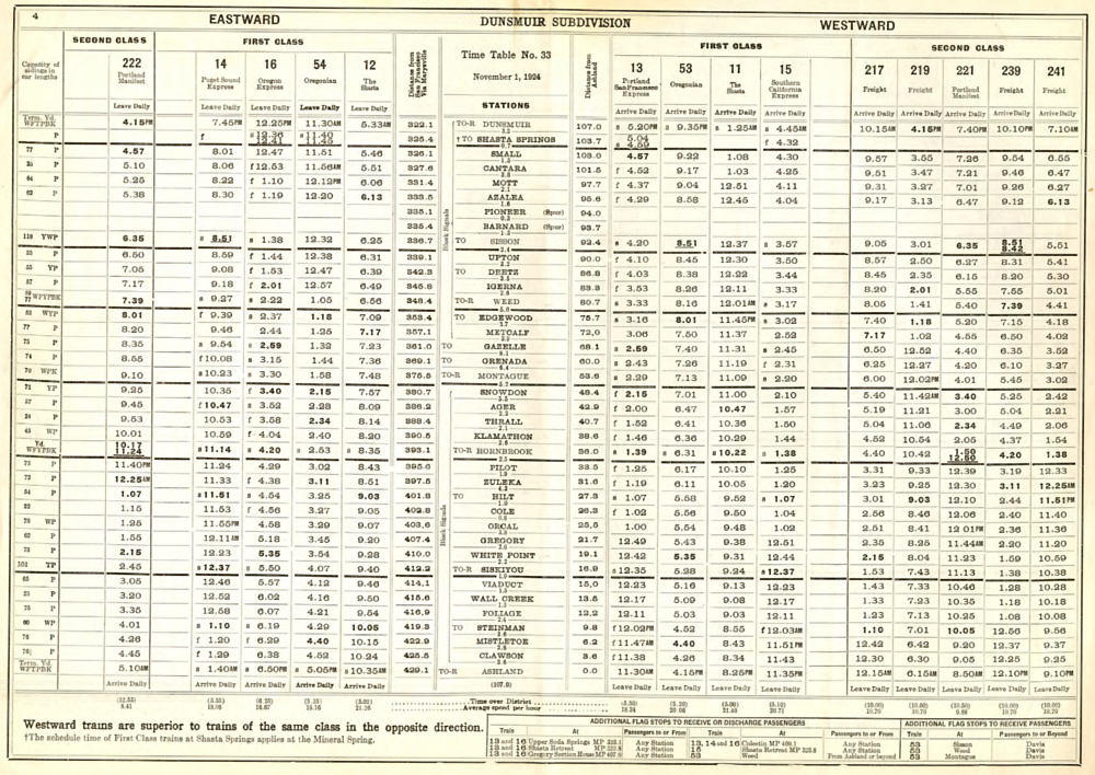
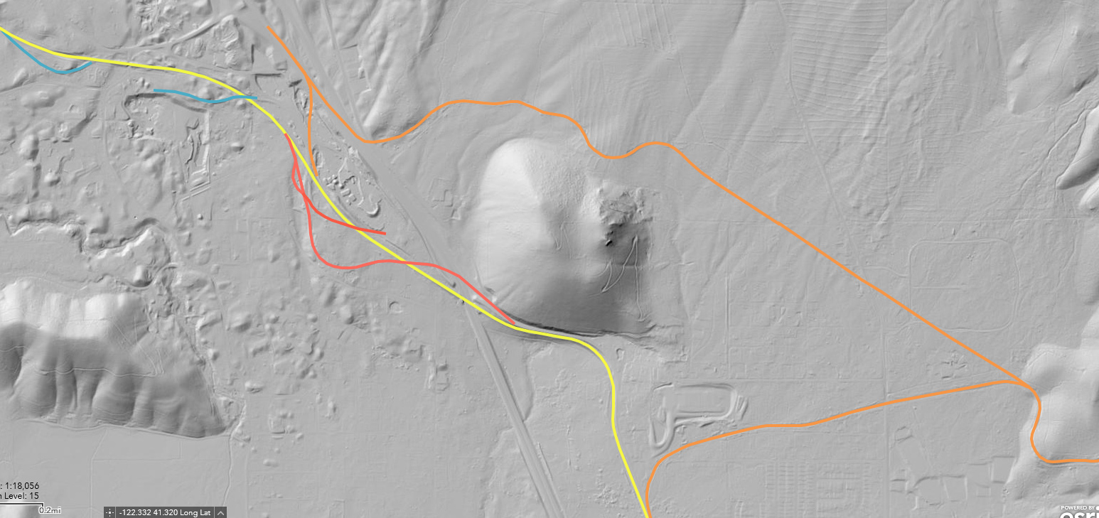
Upton Today's UP right of way is in yellow; original C&O ROW is the right-hand red line, while the 1911 realignment is described by left-hand red line. MRRR is orange, and the switchback switchpoints show in Interstate 5's south bound fast lane. Speculatively, the blue lines trace bits of former C&O ROW. The timetable east end of Upton siding is located at far left, roughly where the blue and yellow lines connect.
Upton-Mt. Shasta Area Both the 1896 and 1907 McCloud River RR ROW's are depicted here, running north and south of Spring Hill, the cinder cone at center. MRRR's switchback was located in I-5's fast lane approximately at the tiny arrow to the left of the Mountain Medics I.D. The longer red line is C&O's 1887 main, while the point where it crosses the yellow line is the approximate west end of today's Upton siding. The current east end is located at roughly where the upper blue line intersects the yellow line at upper left.
Google Maps
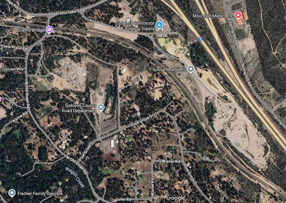
Upton landmarks Union Pacific's Upton Siding's endpoints are at the upper left and lower right corners. Sousa's ex SP gravel quarry is quite evident at mid/lower right, while the crescent-shaped area at the Sousa I.D. was once occupied by one or more SP tracks connected with the main at either end of the crescent. Wx4 Staff recalls picking up cars inside the east switch back in the 1980's, but the east switch is now gone.
|
|
|