|
|
|
|
xxThis page is a follow up to a Wx4's Whatzit? Contest asking for the photo's location. For the record, Evan Josa was awarded a
xxfine virtual selection of canned Bulgarian peas for the correct guess. - EO |
|
|
Post-Flood on Southern Pacific at Bay Point, California, 1911
atmospheric rivers are not a new thing
|
|
 click on image for enlarged version; postcard photo from Wx4 Collection
|
|
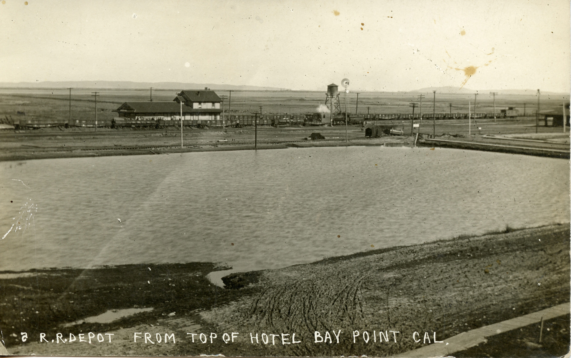
Bay Point was a wide open and quite soggy place adjacent to the marshes when an unknown photographer set up his camera in window of the town's tiny hotel to record the above image of town's railroads set against the backgroun of Suisun Bay. Central to the photo is Southern Pacific's new Type 22 depot which, according to depot historian Henry Bender, the company erected circa 1909 to replace a smaller structure of unknown vintage. Bay Point was not much before the Charles A. Smith Lumber Company set up a large mill here in 1906-07 to resaw lumber produced at its new Coos Bay, Oregon plant. Smith located his operation and associated community on the Bay shoreline just to the left of the photo
There's a bit of action going on. The photographer managed to catch one of SP's 2-6-0's backing a with a train of dump cars at mid dump. This suggests that the photo date was recent to the depot's construction, but the parallel track that runs adjacent to the flooded area gives us a more accurate timeframe. This is the Oakland & Antioch Railway, and it is fairly evident in the photo that it was in the process of construction. Note the construction equipment sitting on very uneven-looking rail below the SP loco's tender, as well as the trolley poles lacking arms. According to newspaper articles reproduced in Ira Swett's Sacramento Northern (1981 edition, pg. 110), construction of the interurban began at Bay Point on Novemeber 22, 1910, and the first car traveled over the line down to Concord on February 13, 1911.
|
|
 click on image for enlarged version; postcard photo from Wx4 Collection
|
Those floodwaters may have been the actual inspiration for the photograph, the result of an atmospheric river similar to the one hitting Central California as these words are written eleven decades later. In January, 1911, the San Joaquin River experienced historic floods, and one particular storm from January 9th to 14th hit particularly hard in a line that extended from Los Gatos through Bay Point to Galt. Thirteen weather stations in that line reported six day rainfall total records that still stand, including Los Gatos's 17.34 inches
What we likely see here is the aftermath, when the waters had receded a little. SP is in the middle of raising its tracks, whiles it appears that Oakland & Antioch's right of way still looks too water-logged for remediation. The photo thus probably dates to the last week or two of January, 1911.
|
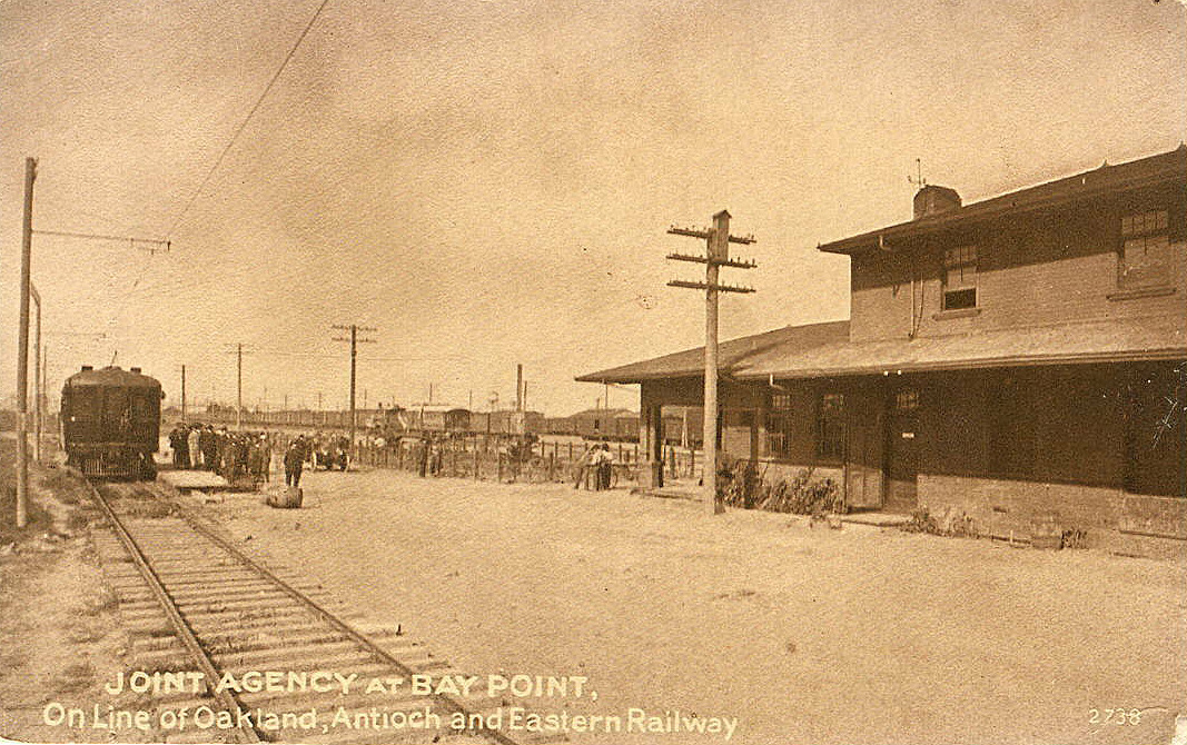
An expanded Oakland & Antioch became Oakland, Antioch & Eastern about a year and a half after its first train. In 1928 OA&E became part of Sacramento Northern. Above we see the interurban's rude facility next to the Santa Fe depot not long after the name change. The Southern Pacific depot roof is barely visible above the boxcar roofs framed by the Santa Fe building's overhang.
|
SP and O&A were not the only railroads that served Bay Point in 1911. The little burg actually touted four. Bay Point & Clayton, a shortline constructed by the Henry Cowell Lime & Cement Company in 1907 ran nine miles south from a wharf near the Smith mill to a cement plant at company town of Cowell. In 1947, the U. S. Navy aquired the line and still operates a large portion of it to serve the Port Chicago Naval Weapons Magazine, which infamously blew sky high in 1944, killing 320 sailors and civilians, about two-thirds of whom were black Navy stevadores.
The fourth railroad was Santa Fe, whose route had been constructed by San Francisco & San Joaquin Valley Railway less than a dozen years before (SP's "Mococco" Line dated to 1878). One corner of its depot appears at the photo's right edge.
Bay Point rebranded itself as Port Chicago in 1931, and the Naval Munitions Station likewise later found itself renamed as Concord Naval Weapons Station. As such, the latter was responsible for the purchase and dismantling of the town in 1968-69 to provide a safety zone around the munitions' perimeter, should 1944 repeat itself. |
 click on image for enlarged version; Google Books
|
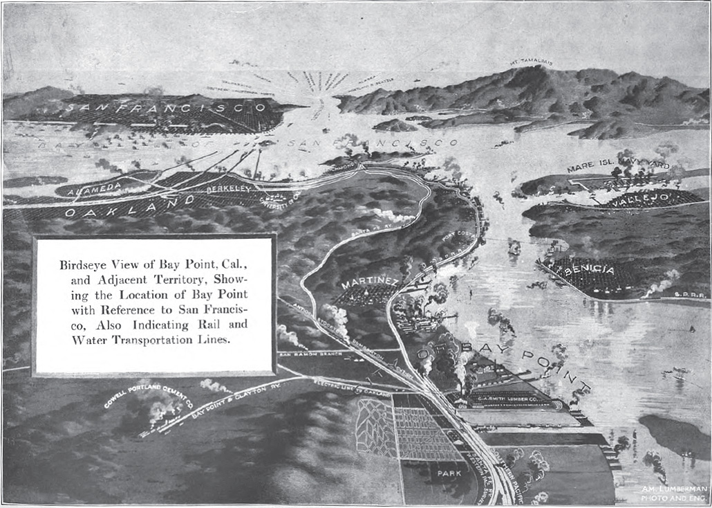
Prominent in this aerial drawing of the Bay Point environs is the mill and yards of C. A. Smith Lumber Company, which was fed by the company's huge mill (then the world's largest) on Coos Bay near Marshfield. In those days, the economies of Coos Bay and the San Francisco Bay Area (rather than Portland) economies were inextricably linked - wags called Marshfield a suburb of San Francisco. This drawing appeared in the American Lumberman, which devoted 101 illustrated pages of its November 11, 1911 issue to the two Smith operations.
|
 click on image for enlarged version; SP Co. photo, Wx4 Collection
|
 click on image for enlarged version; postcard photo from Wx4 Collection
|
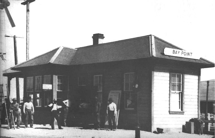
| above: The train order board next to Bay Point's original depot indicates that this photo was recorded late in the structure's existence. In 1901, it had no train order operator, but in 1908 a night operator was on duty. In 1911 the new depot was manned 24 hours day. In fact, this may be an image of the building on retirement day, as it appears that the group of apparent workmen has already removed a couple of doors and more significantly, may be preparing to attack the train order board for removal to the new depot. |
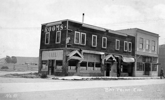
As far as can be determined, the above was the hotel where the the photographer perched to take his post-flood shot. Here we see it somewhat past its glory sometime in the 20's. That it was enough of a landmark to merit a photo postcard tells us quite a bit about the rough and tumble nature of Smith's mill town. From appearances, the building could have been used for any of a number of tawdry purposes. Even though Smith sold town plots with CC&R's prohibiting sale of alcohol, the mill workers were not to be denied, and in consequence, blind pigs and bootleggers flourished. Things became so out of hand that in 1916 Smith relented and allowed one bar to be established, a municipal one run by the town. |
|
For further investigation: East Bay Hills Project has a nice collection of maps and photos of "Old Bay Point". A 1936 Bay Point & Clayton employee timetable pdf is available on Wx4, courtesy of Tim Zukas. |
|
|
|
|
|
|